


One of the reasons some long range forecasts call for a "typical" climatogical forecast for Winter, such as playing the usual "el nino" or "la nina"
climatology forecast, is because in the past, those ENSO states have given a typical 30 year pattern. However, starting about 10 years ago, the various
multi-decadal indicies have been in a phase change, and as we've seen with many long range Winter Forecasts (and Summer),and if you don't account for the phase changes and overlappings, the outlooks have busted. Just last year, most every forecaster went with a traditional "la nina" temperature and precipitation pattern map forecast across the United States, but that
didnt' work out.(self included).
Even though short range weather forecast accuracy has increased tremendously through much better weather modeling and real-time data input, the long range
forecasts leave a lot to be desired. But, that is changing quickly I think. More and more is being learned quickly with using all the various indicies, such
as PDO (pacific-decadal oscillation), NAO (north atlantic oscillation), and a host of other oscillations and forcings around the globe, all of which tie in
with the main forcing from either "El Nino", "La Nina" or neutral state. We're still a ways off from getting long range forecasting accurate enough to be
truly viable to the average person, but some forecasters are really working hard at getting it right.
Aside from the main players, there's a few new pieces to add to the puzzle, but I won't get technical with the use of those, even though they may be just as important as those mentioned above. Things like Geo-magnetism, solar wind, and tropical forcing in the Pacific can alter the overall flow around the globe. At current, we are still in a relaxed period of sunspot activity and it's not rising as fast as once thought. It's believed the relative minimum sunspot activity that led to the Dalton and Maunder time frame cold periods in western Europe and the United States has some correlation in the basically cold period of the time around the 1600's and again in the late 1800's, then it rose during the 1900's, roughly speaking. The trend lately has been down, but there are spikes within decades so it's difficult to make an accurate, strategic year to year correlation.
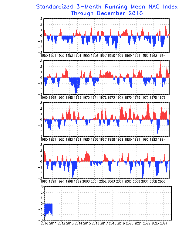
A much better index to predict the overall temperature pattern in the Eastern United States especially, is the North Atlantic Oscillation. If you look at the graph, you can see that its state corresponds pretty nicely with what kind of temperatures occurred in the Eastern US, and fits almost perfectly to the year. In laymen's terms, a negative NAO simply means a strong high pressure has closed off and is a bubble of warmer air over Greenland or thereabouts (there are east and west based versions). A positive NAO means there is no high pressure there, and thus, the air in Canada moves more eastward, not southbound such that occurs during negative phases. Again, there are spikes within the phases, but overall, a negative phase of the NAO usually directly relates to "cold and stormy" in the eastern United States, and that has been exactly the case for each of the past three Winters. Once we can accurately forecast the long range state of the NAO, we can much more accurately forecast the temperature profiles. As of now, we can only forecast it several weeks in advance, but here's the caveat: I've been forecasting a much more negative state to the NAO for a couple of years now, and the long term 30 year trend is obvious...we're in for colder Winters. This index, in my opinion, trumps them all. The big snows and cold of the past several years in the MidAtlantic, Northeast and even Southern Appalachians and interior Southeast directly fall in line with the negative NAO states. The same can be said basically speaking for the 1960's, the late 1970's and the late 1800's...when the NAO goes negative, regardless of ENSO state, snowfall becomes above normal and temperature goes below normal. In the last few years, the NAO has been running negative for an unusually long time, and rivals the cold 1960's, late 1970's and late 1800's. The trend on the graph is pretty obvious, we're in a long term 30 year cycle of negative NAO. Much like the enhanced hurricane activity prediction that came out in the 1990's, there are just some signs we can see that point to a period in general, and this is one of those periods. Just like though we can't say for sure any one particular year won't be the exception , for example, not every year in the last 10 has been extremely hurricane active, overall, the trend can be seen with some certainty. And for the next 25 years roughly, the Eastern United States is in store for more unusually cold, and active weather, but there are those spikes within phases, that will be the exception to the rule. So the bottom line is there are phases within phases, those "spikes", and looking back at actual data regarding temps and precip, we can clearly see the overall graph points to enhanced NAO blocking, which means cold and stormy during Winter.
So for this Winter, I'm predicting another below normal temperature and very active period in the Southeast, Tennessee, Valley and lower MidAtlantic/Interior Southeast, with a quiet Southwest and Southern Plains. The difference this year could be the enhanced shortwaves generating more storminess in the East as La Nina could weaken toward the first of the year. Already, the pattern this Fall has been increased shortwaves and there are signs of Greenland Blocking, with several strong damming episodes occurring, particularly in the Carolinas and Virginia. We can't predict damming months in advance, but the damming events have been lacking the last several years and the fact they've shown up lately is probably a clue that we're not done with those.
I'm not forecasting above normal precipitation in the Southeast states, but only Florida and the immediate surrounding region should be below normal...the rest should be around normal thanks to an active stream with more embedded shortwaves than last season. Most precip events will still be rain, but I'm expecting enough cold air for there to be above normal snow in the southern Apps and Tennessee Valley, and the odds of one significant ice storm in the damming regions is fairly high this year, thanks to the precedent damming already seen,the fact that temperatures will likely be below normal, and the fact storm tracks are supressed, plus odds favor one anytime since it's been a while. I'd actually be pretty suprised to NOT have a major ice event from northeast Georgia to the central Carolinas and southern Virginia this Winter.


wow charlotte nc bieng hit on the spot 4 winterrrrrrr
ReplyDeleteThis one didnt pan out, so far with the current forcast of a bermuda High Building..
ReplyDelete