 | |
| Tornado Outbreak Wednesday April 27 and Thursday 28, 2011 |

Sunday, April 24, 2011
Tornado Outbreak now LIKELY across MidSouth, Appalachians, part of Eastern US
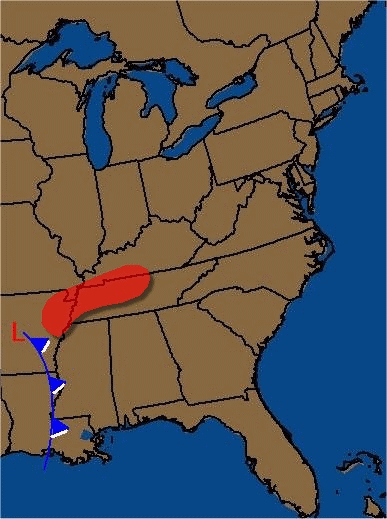
Keep a close eye to updated weather forecasts this week...its going to turn severe once again. The energy for the new tornado outbreak will come screaming down from the Rockies early Wednesday and spawn a rapidly deepening low near the Ozarks of Arkansas. Jetstream winds will have extra speed and lift of 130mph, then shoot due north later in the day, which will help an explosive diffluent pattern over the TENN Valley by midday. This means the likely area of tornadoes will lie across western to central TN and western KY early Wednesday, then orient more north to south as the strong front begins to bow rapidly as the storm center approaches Ohio and then Detroit by early Thursday. The shear factor is going to be about the highest possible, making the environment turbulent and twisting violently just above the surface. This will allow any strong thunderstorm to surge updrafts strong enough to spawn the funnels. This outbreak looks very similar to the event in early April across the Tenn. Valley and Carolinas and Georgia.
The red shading shows where I think the best chance of twisters will occur. The animation begins early Wednesday and the four frames run through early Thursday morning. I'll be able to nail down the timing and location better as time approaches, but each new run of the computer models looks equally as bad as the previous, and this is a dangerous looking situation for a large chunk of real estate. Anyone ahead of the front (and not shown in the red zone) is still at risk of tornadoes and high winds, hail and strong thunderstorms, so don't assume your area is safe.
Subscribe to:
Post Comments (Atom)
No comments:
Post a Comment