Sunday, November 27, 2011

What a Storm! Deep Cut- Off Low to bring Rain, Winds, Snow To South

The models have been showing a developing deep "cutoff" low for a while now and its developing now. Heavy rain will pull up from the Gulf across the Southeast Sunday and Monday, reaching the western Carolinas late Monday. Some impressive rain totals will occur in northern GA and the mountains of NC with this, possibly topping 5".  Meanwhile cold air will wrap around the low and rain will change to snow in Memphis and western Tennessee and northern Mississippi on Monday, and spread deeper into Mississippi and northern Alabama by late Monday night.
The cold air will wrap completely around the low in Mississippi and Alabama overnight Monday night and a snow band will likely spread across central and northern parts of Mississippi, Alabama and Georgia by Tuesday morning, possibly even producing a few flakes in the western Carolina foothills and western Piedmont by Tuesday afternoon as the cold core aloft comes directly overhead. By then snow will be falling in the mountains of TN and NC as the system begins to pull north into the MidAtlantic (rain there), but snow for the mountains.  A very unusual system, and will likely go down as "historic" with standard deviations 4 to 5 SD below normal.

Friday, November 25, 2011

Major Storm in Deep South/Southeast Heavy rain/Wet Snow for some

I could keep on waiting for the runs to keep coming out but the trend is fully back to a cutoff. And maybe further west than the Miss. River but for now I'm settling on around MEM or TN/MS border region, possibly beginning in central Arkansas. As the low cuts off it will continue to tighten and strengthen up, and actually grow colder at the core. However this is still not a really cold cutoff, and the further west it cuts off, probably the warmer it would be, the further east in the TN valley, the colder, thanks to having a longer connection with the northern stream before pinching off.  This is going to be a very big deal.  Its' not often we get 4 or 5 contours closed off this far south.  The GFS seems to have had the right idea nearly a week ago, and pretty much all the ensembles and ops. have settled on a lower Miss or Tn. Valley strong cutoff that could pinwheel for acouple of days if not more.
The models are frequently too quick to move a cutoff (think Sept. Ohio Valley deep cutoff that sat a week). But for now, it appears we're in for a strong southerly fetch against a strong, very sharp trough that creates exceptionally good lift and a tap with the Gulf, so thunderstorms and severe is possible but I haven't seen too much of the severe parameters. Normally a cutoff in this location will funnel heavy but sort of narrow band that trains over the same areas, and that looks to be straight up through Alabama and western GA into Tenn. curving back into a developing axis of deformation. On the northwest side, precip may get an extra lift later on all th way to the Ohio River and southern Illinois.
The rain will probably come in atleast a couple good bands each producing a couple of inches for part of GA and Al, and the western Carolinas. Dynamics weaken further north but later on the storm could phase with another incoming trough, in which case the whole system would strengthen, and become a major snow maker for inland Northeast, but thats very far out.
As the cold air aloft begins to wrap on the west side, then rotate under the 850 low around MEM, rain may change to snow in central Ark, northern Miss even down to central Miss, nrn La and spread into western Alabama later on if the core of the lowest heights go toward the Tenn. River Valley and then southern Apps region.  Time of day and precip rates will mean everything since we're dealing with marginal air and climo this time of year, but usually strong cutoffs of this caliber are capable of dyamic cooling down to the surface (even in daylight if heavy enough), but can vary tremendously from one city to the next. This could be a situation where at one point its snowing in Jackson Mississippi and raining in Nashville.  And then snowing in Nashville but raining in Pittsburg. Depends on the location of the core and the wrap around moisture and precip rates.
Another major aspect will be the rain totals and rainfall rates. The models are pretty widespread and heavy through the Tenn Valley and probably not quite heavy enough in the Apps.  If it cuts off too far west, that would reduce the totals for the southern facing Apps of northeast GA and western NC, but with the ensembles and most models showing the nature, location and orientation of the 3 to 5 contour cutoff, easily flooding type rains could be a problem esp. if it comes at rates like .50" an hour for 6 plus hours, which is very possible in one or more of the heavy bands that rotates through.
I think most have seen what strong cutoff lows are capable of, and keep in mind the models and soundings and such aren't gospel..these things do strange things all the time. And this particular one is one of the strongest I've seen modeled this far south. I'm sure there's been others but not lately, and not in the Deep South, and not at this time of year.  Anything is possible and I'd bet the models have a trick up their sleeve yet, for example, possible phasing with another wave later next week if the system hangs around very long in the South. Or the system may end up further west, which would mean it won't be as cold core, so very little snow at all.  This is my best call for now.  I'm finishing this up and the 00zNAM is in. Nothing really to change my mind except to re-iterate, this is going to be a very big deal across the South. Lots of rain, hour to hour vast weather changes, and from city to city in the same state. If you like interesting weather, this should suit you on many levels. And for the snowlovers, as long as the models don't begin getting warmer with the cold intrusion, I think a surprise snow report will occur Sunday night , Monday or Monday night into Tuesday "somewhere".  As always, have fun with this storm! Its' been a blast to follow all week long.

Saturday, November 12, 2011

Warming Up Soon

A widespread hard freeze this Saturday morning in the Southeast states, but the high pressure will slide offshore today and strong return flow begins as early as this afternoon... Translation: warm up begins this afternoon for most of us, and will be in full force by Sunday afternoon.

Projected rainfall from the Tuesday night/Wednesday system
Our next rain should arrive Tuesday afternoon and then that slides quickly off the east coast. It appears one system after another should arrive over the next 10 days, but we won't be dealing with cold air in the East again until after the middle of the month, probably toward the end of the month as the cold air in Canada slides into the Rockies and western states.  Once the flow re-aligns later this month or early in December, some truly cold arctic air may start to arrive and then begin a series of Winter storms across part of the country.  Enjoy the mild break in the weather.

Thursday, October 27, 2011

Snow and Sleet In NC Mountains, Followed by First Widespread Frost

A rapidly developing East Coast storm will spread cold rain over the Carolinas and north Georgia Friday afternoon, when temperatures will drop almost 30 degrees from where they will be on Thursday afternoon. Look for temperatures to hold steady in the upper 40's across western NC in places like Hickory and Charlotte, after being in the 70's just a day before.  Meanwhile the air aloft will get cold enough to produce snow in the northern mountains of NC and southwest Virginia by Friday night and Saturday. I can't say how much precip will fall at this time, but it could be significant enough for accumulations overnight and early Saturday morning, as the storm strengthens going up the East Coast.
Big Switch From Thursday into Friday and Early Saturday along the East Coast
Sun sunshine could break out later Saturday afternoon, as the clear skies and high pressure build in, but here comes the Carolinas first widespread frost and freeze. By Sunday morning, the heavy dew will have turned to an icing of frost across many a windshield by dawn, with temperatures all across the piedmont in the low to mid 30's, with some upper 20's in the foothills and mountains.  By Sunday afternoon we will have a beautiful sunny, but still chilly, day.

Sunday, October 16, 2011

Rapid Changes This Week...Big Storm, then Colder and Windy

A deepening storm will begin in the northern Gulf and drench Florida Monday and Tuesday, while spreading quickly developing rain in Georgia and the Carolinas late Tuesday and into Wednesday, before really turning into a major system for the East Coast mid week. By the time the storm closes off and occludes in upstate New York, enough cold air will have spread down the Appalachian Chain early Thursday morning for the Flakes to be falling once again, for the higher elevations.
The rest of the Eastern US will be clearing out, but windy and colder. By Friday and Saturday mornings, frost may be a concern in the Ohio Valley and Tennessee Valley, even down into northern Mississippi, Alabama Georgia and the Carolinas by Saturday morning as the winds go calm directly underneath high pressure. A very active week coming up!

Friday, October 14, 2011

Winter Outlook 2011-2012 ... Cold And Stormy Midwest to Southeast


One of the reasons some long range forecasts call for a "typical" climatogical forecast for Winter, such as playing the usual "el nino" or "la nina"
climatology forecast, is because in the past, those ENSO states have given a typical 30 year pattern. However, starting about 10 years ago, the various
multi-decadal indicies have been in a phase change, and as we've seen with many long range Winter Forecasts (and Summer),and if you don't account for the phase changes and overlappings, the outlooks have busted. Just last year, most every forecaster went with a traditional "la nina" temperature and precipitation pattern map forecast across the United States, but that
didnt' work out.(self included).
Even though short range weather forecast accuracy has increased tremendously through much better weather modeling and real-time data input, the long range
forecasts leave a lot to be desired. But, that is changing quickly I think. More and more is being learned quickly with using all the various indicies, such
as PDO (pacific-decadal oscillation), NAO (north atlantic oscillation), and a host of other oscillations and forcings around the globe, all of which tie in
with the main forcing from either "El Nino", "La Nina" or neutral state. We're still a ways off from getting long range forecasting accurate enough to be
truly viable to the average person, but some forecasters are really working hard at getting it right.
Aside from the main players, there's a few new pieces to add to the puzzle, but I won't get technical with the use of those, even though they may be just as important as those mentioned above. Things like Geo-magnetism, solar wind, and tropical forcing in the Pacific can alter the overall flow around the globe. At current, we are still in a relaxed period of sunspot activity and it's not rising as fast as once thought. It's believed the relative minimum sunspot activity that led to the Dalton and Maunder time frame cold periods in western Europe and the United States has some correlation in the basically cold period of the time around the 1600's and again in the late 1800's, then it rose during the 1900's, roughly speaking. The trend lately has been down, but there are spikes within decades so it's difficult to make an accurate, strategic year to year correlation.
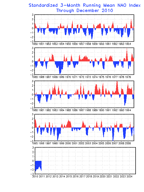
A much better index to predict the overall temperature pattern in the Eastern United States especially, is the North Atlantic Oscillation. If you look at the graph, you can see that its state corresponds pretty nicely with what kind of temperatures occurred in the Eastern US, and fits almost perfectly to the year. In laymen's terms, a negative NAO simply means a strong high pressure has closed off and is a bubble of warmer air over Greenland or thereabouts (there are east and west based versions). A positive NAO means there is no high pressure there, and thus, the air in Canada moves more eastward, not southbound such that occurs during negative phases. Again, there are spikes within the phases, but overall, a negative phase of the NAO usually directly relates to "cold and stormy" in the eastern United States, and that has been exactly the case for each of the past three Winters. Once we can accurately forecast the long range state of the NAO, we can much more accurately forecast the temperature profiles. As of now, we can only forecast it several weeks in advance, but here's the caveat: I've been forecasting a much more negative state to the NAO for a couple of years now, and the long term 30 year trend is obvious...we're in for colder Winters. This index, in my opinion, trumps them all. The big snows and cold of the past several years in the MidAtlantic, Northeast and even Southern Appalachians and interior Southeast directly fall in line with the negative NAO states. The same can be said basically speaking for the 1960's, the late 1970's and the late 1800's...when the NAO goes negative, regardless of ENSO state, snowfall becomes above normal and temperature goes below normal. In the last few years, the NAO has been running negative for an unusually long time, and rivals the cold 1960's, late 1970's and late 1800's. The trend on the graph is pretty obvious, we're in a long term 30 year cycle of negative NAO. Much like the enhanced hurricane activity prediction that came out in the 1990's, there are just some signs we can see that point to a period in general, and this is one of those periods. Just like though we can't say for sure any one particular year won't be the exception , for example, not every year in the last 10 has been extremely hurricane active, overall, the trend can be seen with some certainty. And for the next 25 years roughly, the Eastern United States is in store for more unusually cold, and active weather, but there are those spikes within phases, that will be the exception to the rule. So the bottom line is there are phases within phases, those "spikes", and looking back at actual data regarding temps and precip, we can clearly see the overall graph points to enhanced NAO blocking, which means cold and stormy during Winter.
So for this Winter, I'm predicting another below normal temperature and very active period in the Southeast, Tennessee, Valley and lower MidAtlantic/Interior Southeast, with a quiet Southwest and Southern Plains. The difference this year could be the enhanced shortwaves generating more storminess in the East as La Nina could weaken toward the first of the year. Already, the pattern this Fall has been increased shortwaves and there are signs of Greenland Blocking, with several strong damming episodes occurring, particularly in the Carolinas and Virginia. We can't predict damming months in advance, but the damming events have been lacking the last several years and the fact they've shown up lately is probably a clue that we're not done with those.
I'm not forecasting above normal precipitation in the Southeast states, but only Florida and the immediate surrounding region should be below normal...the rest should be around normal thanks to an active stream with more embedded shortwaves than last season. Most precip events will still be rain, but I'm expecting enough cold air for there to be above normal snow in the southern Apps and Tennessee Valley, and the odds of one significant ice storm in the damming regions is fairly high this year, thanks to the precedent damming already seen,the fact that temperatures will likely be below normal, and the fact storm tracks are supressed, plus odds favor one anytime since it's been a while. I'd actually be pretty suprised to NOT have a major ice event from northeast Georgia to the central Carolinas and southern Virginia this Winter.

Monday, September 26, 2011

October Comes in Pretty Cold! First SnowFlakes in Mountains?

The pattern will be changing quickly by Friday afternoon as a strong cold front pushes into the Eastern states. A Canadian High pressure will send a strong cold front crossing the Appalachians late Friday evening and deliver the first widespread, cold and dry airmass of the season into the Southeast. The trough may be deep enough and cold enough to produce the first snowflakes in the higher mountains of West Virginia, northeast Tennessee and western North Carolina at some point on Saturday. But this will only be for the highest of elevations like Roan Mountain, Clingmans Dome, Grandfather and Mt. Mitchell.  The rest of the Southeast will finally clear out of the murky mess that we've endured for almost 2 weeks!  Both Saturday and Sunday mornings will be very chilly in the piedmont of the Carolinas and Georgia, with lows possibly getting into the upper 30's to low 40's.